

On Saturday, March 9, a collaboration between the We Wai Kai Nation and the Water Security Team of Quadra Island Climate Action Network (Quadra ICAN) presented an update of their work over the past year. The presentation was entitled “Water Systems of Quadra Island: Preparing For our Future”.
Their work is currently embodied in three major projects:
- Well monitoring and aquifer mapping
- Stream flow monitoring in salmon bearing streams
- Wetland and watershed mapping
Together, information gathered through these projects will help Quadra Island prepare and plan for the probability that water will become less available in the future. Climate change is an important factor altering the water cycle and is likely to contribute to declining water availability. Increased development, resulting in increased water demand from diminishing aquifers, is another major factor. The Team is hoping to someday use their data in computer models to predict the effects of different scenarios, based on climate and development variables, on water availability.
These same forces—climate change and development—are also affecting water availability on Cortes Island. Long-time Cortes Islanders and intrepid Streamkeepers Christine and Cec Robinson spent that windy day attending the forum. Their hope was to learn about ICAN’s water projects and consider how they might implement similar projects on at home.
“We had a lovely lumpy ride over on the ferry. Bless our ferry that went and returned us!” Christine commented.
Bernie Amell lives on Quadra Island and is the lead on the wetlands project of the Water Security Team. He is known for his work on the design of constructed wetlands for water
treatment and in the restoration of streams and riparian habitats. Amell shared his insights about how the projects fit together.
“There are three projects and they’re interlinked in understanding the full cycle of water on the Island. Because we have to understand the size of the sponge we’re all drawing from.” He said he’s hoping their efforts will inform the upcoming revisions to the Island’s Official Community Plan. “The Team is interested in the Community Plan being based on the best possible understanding of the water resources of the island so the humans don’t use it all up.”
Existing geological maps and well data from the Province have been used to map Quadra Island’s aquifers. Amell said the south end of Quadra, much like the south end of Cortes, is composed of compressed glacial silt and clay over bedrock. Aquifers that supply deep domestic wells are in the sand and gravel between these layers. Surface aquifers exist above the silt and clay layer in some areas and provide water for shallow wells, although they are more unstable and prone to contamination. There are also aquifers in cracks and fissures within the bedrock.
In our region, the only source of recharge for all of these underground water systems is rainfall. Rainwater either flows off the island via streams or penetrates into the aquifers.
Well Monitoring
Monitoring water levels in deep wells provides information about how much water is seeping into the aquifer relative to use. Data collected by the Province from one Quadra Island well shows a dramatic increase in water level variability, with a decline in average levels of almost a meter, over the last 15 years.
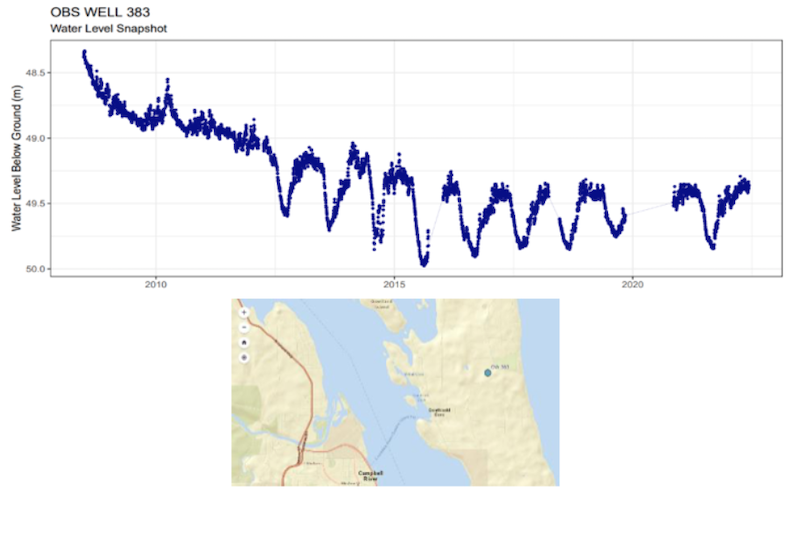
From the ICAN Water Security Ieam Presentation
The Water Security Team and We Wai Kai Nation purchased 18 instruments for monitoring water levels in domestic deep wells. The instruments report water levels every 15 minutes and are providing data from wells distributed around the island. So far, data collection has begun in 13 deep wells, and monitoring shallow wells is expected to begin in 2024. Once they have three to four years of data, useful interpretation will become possible.
Basic information about how many wells there are on Quadra Island is also important for estimating water demand and planning for water shortages. There are 450 registered wells on Quadra Island and the number is growing. The Team highlighted the need for residents with wells to make sure they are registered at the BC Domestic Well Registration website.
Stream Flow Monitoring
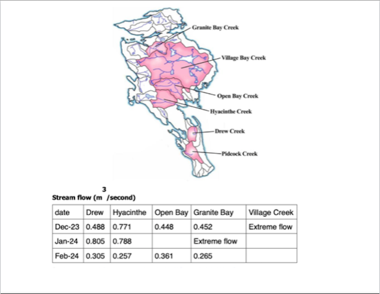
Monitoring stream flow is a means of estimating water leaving Quadra Island. Stream water temperature and other conditions will provide additional information about the health of streams and their ability to bear returning salmon and can be useful as indicators of drought severity.
Two stream flow monitors that use ultrasound doppler technology have been acquired by the ICAN Water Security Team together with the We Wai Kai Nation using Indigenous Watershed Stewardship funds. Volunteer citizen scientists have begun collecting water flow data monthly in five of Quadra Island’s major fish-bearing streams.
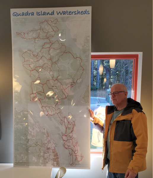
Wetland and Watershed Mapping
Wetlands are important sources of penetrating water that help ensure rainwater gets into aquifers. By identifying wetland locations, more can be done to protect them. The wetland mapping initiative is engaging the community to help identify wetlands by looking for specific land features and plant indicators.
A small field guide featuring six plants has been developed to help people distinguish between seasonal and permanent wetlands. For example, certain sedges will tolerate drying out in the summer and indicate the presence of seasonal water, whereas Spiraea species will only grow where water is always present.
According to project lead Bernie Amell, watershed-mapping citizen scientists are using GPS-to-tablet technology to track the locations of wetland-indicating plants and land features. Monitoring changes in wetlands provides key information about water availability for aquifer recharge and how climate change and human-altered landscapes are impacting the water cycle. It can also be used to guide land protection and development and show where erosion protection strategies might be beneficial.
Why Monitor Water Cycles?
Amell said the work of the Water Security Team is growing roots into the community. He hopes this work will help secure local management of water issues on Quadra Island. Getting the community informed and invested is a form of science-driven “soft” activism, he said, and allows them to speak to government bodies with one voice.
As to the relevance of the project he leads, Amell said, “Understanding watersheds brings people into awareness. From an ecological point of view, a watershed is your real address, where you really live, because the environment and human neighbours are affected, they affect you and you affect them, within your watershed. Understanding what part of the watershed is your home that you share with nature and other people is very important. We’re all in this together, on an island… watershed understanding is understanding your natural neighbourhood.”
Bringing it Home
Christine Robinson has been in touch with several of the presenters from the Water Security Team over the past few months. “They’ve been at this a while,” she said, “They’re very well organized.” She hopes to replicate some of the work they are doing on Cortes Island.
According to Robinson, one of the first steps would be accessing a geological assessment to understand how water moves over the land and how and where the land mass holds water. Some of this was done on Quadra Island through the Provincial Groundwater Observation Network. Robinson thinks there may be similar resources available specific to Cortes Island that would be useful.
Cec Robinson was optimistic about finding people on Cortes willing to participate in well, stream, and wetland monitoring. He also said there may be low-tech ways to estimate water cycles, including stream flow. “Streamkeepers are taught how to [estimate flow] by just measuring the average width and average depth and, taking an object of neutral buoyancy, like an orange, dropping it in the stream and watching how fast it goes by. It’s just basic math that tells you, okay, that’s ‘x’ number of cubic feet per minute.”
Kicking it off, Christine and Cec envision a Saturday afternoon event in which some of the key players in the ICAN’s water security projects can present their work on Cortes Island and help Cortesians envision how they might initiate a similar project at home. Christine commented, “I saw a lot of value in how they framed everything. It was a good overview of how to approach, or what aspects to approach, for us to begin taking a look at water security on Cortes. So, they have been very agreeable to sharing any of their information.”