
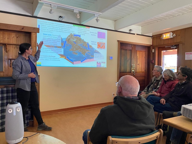
Cortes Island’s aquifer health study has been released and in this morning’s interviews we are speaking with Sylvia Barroso, of GW Solutions, the Senior Hydrologist who participated in this project, Sadhu Johnston, Executive Director of the Cortes Island Housing Society and Mark Vonesch, Regional Director of Cortes Island.
First, there are two key questions at the top of many people’s minds. Is there enough water in Cortes Island’s aquifers to support further development? And why were some of the island’s shallow wells not recharging during the recent drought?
Barroso’s answers to both questions were complex. Aside from her reference to climate change and the fact conditions are going to get worse, you’ll have to wait for her full answer to the question about our shallow wells. However one of her statements about the state of Cortes Island’s aquifers is very illuminating:
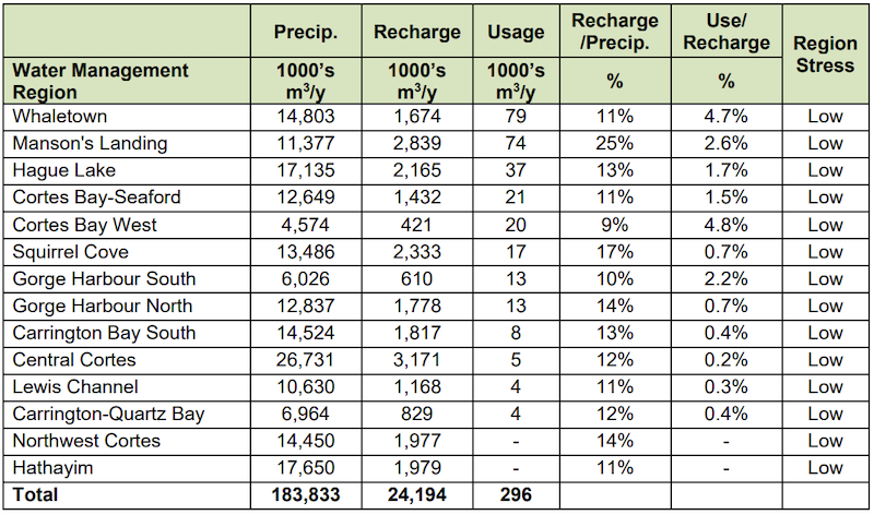
“Our study showed that in general Cortes has abundant water sources and that at the current usage levels, we have not found that there’s overuse. When we look at it from a water management approach, we did not find that any of the water management areas had greater than 5% of the available water being used. That suggests that there is room for growth, and it gives us an opportunity to strategically develop water sources and develop those in protected areas.”
Cortes Currents: The issue is much more complex and there are steps we should take to ensure the health of Cortes Island’s water supply, but for that you have to listen to the long version.
Mark Vonesch explained, “I have friends and family in Southern Gulf Islands and there’s a lot of places where they’re trucking in water and I was concerned that the calls for some increased density and allowing more things to happen in Cortes could have a negative impact. So one of the first things I did was work with the Cortes Housing Society and support them in writing a grant to the Real Estate Foundation at BC to get some funding to do an aquifer study.”
Sadhu Johnston added, “Two years ago we held a housing summit and a lot of people from across the community gave input to the housing society about priorities. One thing that came up loud and clear was environmental concerns and in particular, water issues, water conservation, water supply, and understanding whether we as a community have enough water. So over the last year and a half, we worked to get a grant from the BC Real Estate Foundation, which enabled us to hire GWS Groundwater Solutions. They’re really great hydrologists. They’ve done work on Salt Spring, across the province and other island communities in particular.”
Sylvia Barroso: “On the islands there’s really a lot of interest and passion about water. People will follow those stories and people will seek out information about water because it’s something that is very close to their hearts.”
“I’ve worked for many years in the Gulf Islands region and Discovery Islands, and just seeing people’s interest in water science and passion for water is very interesting.”
“What a great initiative it was that the Housing Society took the initiative to seek out the funding to try to do a study of this kind on Cortes. It shows that local involvement in water issues and the need to understand better the availability of water, the potential impacts to water, and from a planning perspective to be proactive in terms of how development occurs, where development occurs, how water sources are identified and protected and to have an overview of the state of the resource at this time.”
Cortes Currents: Could I ask, exactly what did you do?
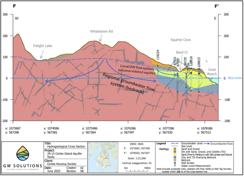
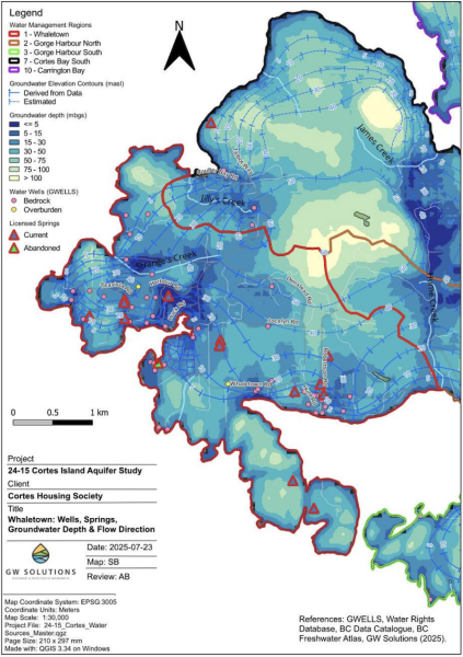
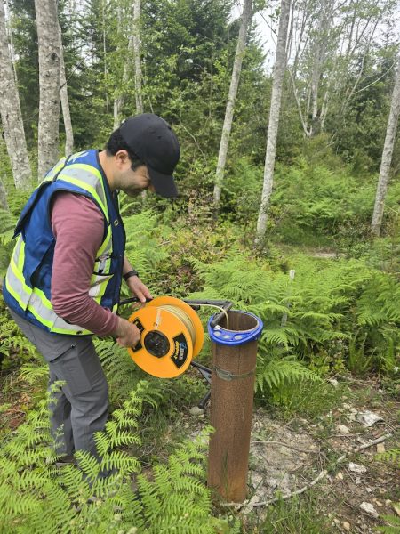
Sylvia Barroso: “ Essentially we’ve done a baseline compilation of water related data for the island. We constructed a three dimensional geologic model of the whole island using available data sets on things like the depth and the properties of materials like sand and gravel and soil overlying the bedrock itself,the geology, the presence of wells, where they are, and the information about those wells, water levels and the depths of the wells. In addition, we completed field assessments to characterize and take observations of local water issues as well as ground truthing, essentially: our model assumptions.”
“One of the things that the model enables us to do is to construct cross sections or a visual representation of the local aquifers, and to try to evaluate the interrelationships between the different aquifer zones as well as the factors that control groundwater movement and flow.”
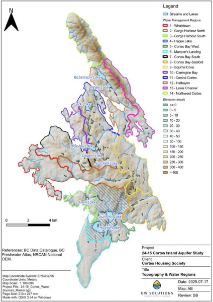
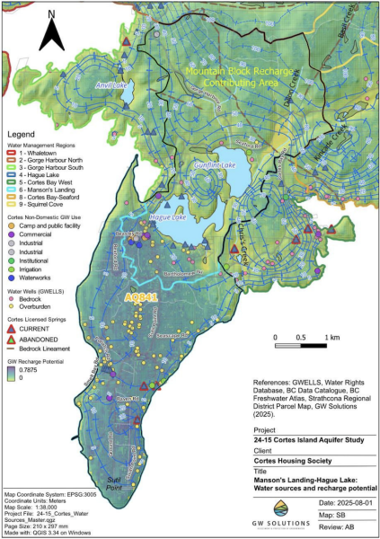
“One of the really interesting things that we highlighted in our report is that connection between the surface water bodies on the island and the underlying aquifers, the aquifers that border the surface water sources. For example, in the Mansons Landing area and the lake system, Gunflint and Hague Lakes lead into the Manson’s landing aquifer, but there is a dynamic interrelationship. So topographically, some flow comes from the Mansons Landing area down toward the lake, but we believe at depth that the lake system is feeding the underlying aquifer.”
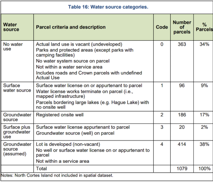
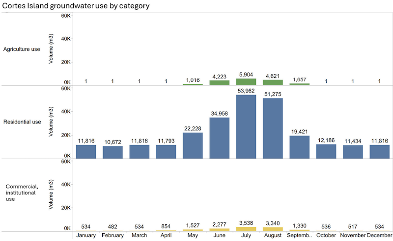
“Essentially we have created a baseline characterization of the water systems on the island, the sources of water, and where water is being used.”
”We also made an estimate of how much water is being used and how much water is being replenished into the local aquifers, and did a comparison of what that ratio is between those two values. So are we utilizing a lot of the available water or a small amount of the available water?”
“It also gives us some direction as to where we are lacking data and where additional data should be collected.”
“One of the things we highlighted was that there are no provincial observation wells located on the island, and there’s only a small number of water users that are monitoring their own either water use, or water levels or quality. That’s a very important message. The next step the community could engage in is development of a local water monitoring network to try to better understand those dynamics and start to track long-term trends in addition to monitoring the lake systems, the river systems, and the groundwater systems to try to better understand those interrelationships and to understand how things are changing over time.”
“We’ve pointed to some very interesting work that’s been done on Quadra Island with the ICAN Network where they have worked with Vancouver Island University. Dr Jerome Lesemann, a hydrogeologist who works for the university, has worked with his students and they’ve done similar work in developing leapfrog model water balance assessments and they’ve worked with the community to identify suitable wells where monitoring can be undertaken. Over time they will start to build that information to be able to understand the dynamics within different areas of the island. I think something similar could happen on Cortes.”
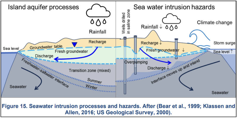
“Another thing that was quite interesting was looking at the hazards and vulnerability to saltwater intrusion.”
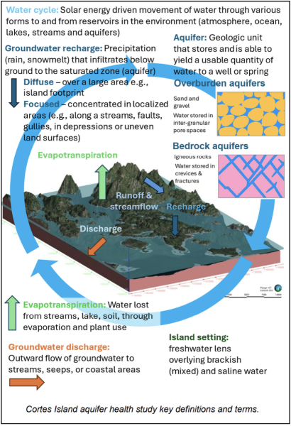
“Within an island setting, fresh water sits as a lens. It has a low density, and underlying that is the saline water. All the water that is available on the island comes in as precipitation all over the footprint of the island itself. There’s no interconnection between the surrounding mountain systems on the mainland or on Vancouver Island. It’s solely sourced locally.”
“Within coastal areas, there can be vulnerability to saltwater intrusion. There is a shallower water lens in those areas. In addition, if wells are drilled too deep, they can intersect that transition zone between fresh and saline water. In the fractured bedrock setting, they can intersect fractures that contain saline water. Also the pumping of wells can draw water levels downward and inland. So sometimes the effects of over pumping can also contribute to salt water intrusion. So when we look at hazards or vulnerabilities that are key within Cortes and in many of the island settings, saltwater intrusion is certainly one that we’re fairly concerned about.”
“What the study highlighted was that the fractured bedrock aquifers, such as in the Whaletown area and in Cortes Bay and to a certain extent, Squirrel Cove, where you have development close to the coast and where you have in particular fractured bedrock aquifers, those areas tend to have a higher vulnerability to sea water intrusion. It’s something that we should continue to monitor and look at in the future. There’s best practices around well drilling, siting and operation and if people find that their wells are starting to go salty, it’s really important to try to limit the groundwater usage and undertake further investigation as to the reason why the water went salty.”
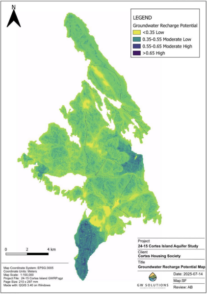
“Looking at water use within the different management areas, there’s different ways to look at that ratio between recharge, groundwater availability, recharge over aquifer footprint, and the water usage.”
“The provincial mapping has some relatively small aquifers, but we chose to look at both the water usage within the aquifer units themselves. We also divided the island into different groundwater management areas based on topography and the direction of groundwater movement and flow.”
“Within each management area, we think that the conditions will relate to one another, water usage and water pumping and that sort of thing will be related to one another. So when we look at it from a water management region approach, we did not find that any of the water management areas had greater than 5% of the available water being used. That suggests that there is room for growth, and it gives us an opportunity to strategically develop water sources and develop those in protected areas.”
“Other area islands have been developed historically prior to an understanding of water science and public health. As an example, on Savary Island they have essentially an urban configuration of very small lots, each with their own well and septic system. The type of density that we see at Savary is probably not something that we would recommend now that we have an understanding of those interactions between wells, septics and sources of recharge and pollution into the aquifer.”
“On Cortes, if additional density is desired, establishing water sources and shared water sources could be an option rather than going to say small lots each with their own septics and well. I believe that’s not the way to move forward based on having completed other work in other areas.”
“Cortes is at the point where the majority of lots are large and the Housing Society’s development of the Rainbow Ridge is a perfect example of where you have a community water supply being developed strategically and you’re having higher housing density in a planned manner.”
“Having shared water sources, community water supplies, is an important aspect and maintaining larger lot sizes if the desire is to continue with, say, that model of one well, one septic per lot.”
Cortes Currents: My second question is related to shallow wells, specifically some of the shallow wells that stopped charging during the recent drought.
Sylvia Barroso: “One of the things that the geological model allows us to do is to interpret the relative depths of the different material types. So say for example, if you were to drill down into the earth you might find a layer of soil at the top, and then underneath that you’ll find different geologic layers that mostly reflect the glacial history of this area.”
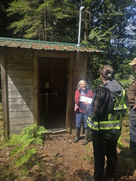
“What we found was that there are a large number of springs and likely shallow wells (dug wells) that have been used historically as water sources on the island and continue to be used in some areas.”
“What is likely occurring is that those wells intersect a permeable layer of gravel that overlies a less permeable layer, such as thick deposits of silt, clay type material that we call confining material. When water infiltrates into the ground surface, it will move quickly through more permeable materials like loose sand and gravel and then when it hits a silt or clay layer, it will move more slowly.”
“A deeper aquifer, such as the Mansons Landing aquifer that is below a layer of confining material, is provided with some protection from contamination at the land surface.”
“Historically when these shallow sources were constructed, they probably dug down until they found a usable quantity of water, but often those were above that confining layer. As the water infiltrated into the ground, it reached a barrier provided by that low permeability material. It would collect above that layer. If i hits bedrock water is not able to pass down immediately through the bedrock and will preferentially pass down into fractures that are connected at a certain point. So the water will flow along that contact or interface between the loose, unconsolidated materials, , and the rock itself.”
“Often that zone immediately above the bedrock is where shallow wells can be constructed and obtain the usable quantity of water. What we’re seeing in the current climate change conditions is that we’re having much longer dry seasons, so we’re having longer periods of time when we’re having less rainfall over the summer period.”
“So we see, for example, precipitation declining earlier in the spring and that period of dry conditions extending into the fall. Those shallow deposits are replenished more readily through rainfall events. That longer dry season will mean that those shallower deposits will likely dry up, so shallower springs and shallow dug wells may be more vulnerable too. Whereas the deeper aquifer is replenished over a longer timeframe, and it has more storage left in it that can be utilized during those periods of dryness.”
“We’ve developed this baseline assessment of water availability on the island, but we recognize that there’s gaps in information. In particular, the lack of local monitoring networks, so developing those local monitoring networks and seeking opportunities for water users to collect information, collecting information about the lakes and river systems and their seasonal conditions, water levels, etc. Strategically developing a monitoring network is likely a priority for the community to try to really continue to build on the understanding now that we have this foundational work that we’ve completed.”
Cortes Currents: Do you have any other suggestions for those of us with shallow wells?
Sylvia Barroso: “Definitely storage and utilizing a range of different sources. If a drilled well is not viable at a property, going to rainwater catchment is an option and obviously practicing water conservation.”
“The other thing about the shallow dug wells that I’ve noted, is that those sources can often be very vulnerable to contamination. So if a person is utilizing a shallow source like a spring or a dug well, it’s really important to have some sort of UV system or some sort of disinfection method because those sources can be vulnerable to contamination and may contain coliform bacteria or other pathogens.”
“One thing that I think would be really helpful also for the community is to improve education amongst well owners as to how to maintain their wells. They should test their water quality. Look out for protection of the well itself, the physical construction as well as keeping track of maintenance records and that sort of thing. In other communities, they have education programs.”
“A WellSmart program is an example that is undertaken in the Regional District of Nanaimo. Those programs provide invaluable information for well owners as to how to protect their water sources and maintain them so that their investment is protected and that their health and the viability of their property is protected.”
“The Regional District of Nanaimo provides a really excellent model. They have developed a drinking water and watershed protection program. Through that program, they’ve invested in both scientific studies such as Cortes Housing Society has initiated on Cortes. In addition, the Nanaimo Regional District offers rebate programs for rural well owners for well testing as well as well upgrades. That has been an invaluable program that allows people to make upgrades to their well, where financial barriers may be a consideration. So it subsidizes up to a certain value and then the homeowner also has to contribute a portion. That has enabled more people to access well testing for water quality as well as repairing their wells, so that they’re properly set up and protected from contamination. They also offer a rebate program for decommissioning of unused wells.”
“Unused wells can be a conduit to contamination into an aquifer if they are abandoned and left open. So decommissioning of unused wells is a really important aspect for aquifer protection,. Sometimes wells are left in a variable state, such as a piece of wood on top or a tarp or something that’s not secure, and that can be a safety hazard as well.”
“Something that folks should be aware of, if they’re not using the wells, they should be properly maintained or decommissioned.”
“It would be interesting for the Strathcona Regional District to consider what supports they provide to rural property owners because they are rate payers and essentially they’re providing a service by providing their own water supply, but they can be supported to do that in an effective manner through those types of programs.”
Sadhu Johnston: “This isn’t just something that the Housing Society can do on our own. We need to be working together as a community, but there are recommendations that we use this study and the work that we’ve done so far as really a first step. We need a well monitoring program on Cortes, and that’s going to be really important for us to track over time how people’s wells are performing. We need well education so people understand what kind of testing and even water use consumption can be added to your well. So you can see if you’ve got leaks or just to understand how much you’re consuming.”
“There are other islands in our region that are really suffering from water shortages and we need to learn from their experiences and undertake this work now before it becomes a problem on Cortes. There’s definitely good news in this report, but also very clear recommendations for things that we need to do as a community now so that we can protect this resource in the future.”
“As a housing society, we’re going to be looking to raise funds and to embark on a well monitoring program and doing some of the other elements that were recommendations from the report and really encourage people to think about their own water consumption and and start to implement some of the recommendations. The full report is online on the Cortes Housing Society website, which is cortescommunityhousing.org.”
Links of Interest:
- Cortes Island Aquifer Health Assessment – GW Solutions
- GW Solutions website
- Articles about, or mentioning Cortes Island’s aquifers – Cortes Currents
- Articles about, or mentioning, Quadra Island’s aquifers – Cortes Currents
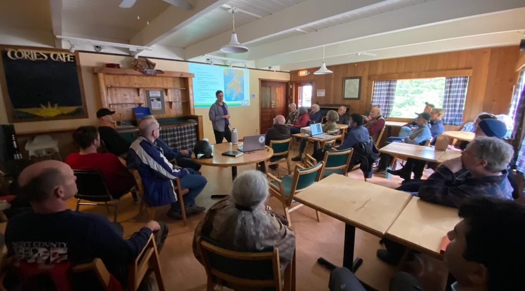
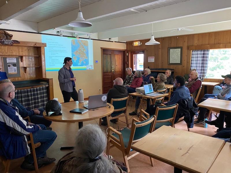
Top image credit: Sylvia Barroso speaking to Cortes residents in the Pioneer Room, Mansons Hall – Photo courtesy Cortes Housing Society; all graphs and maps taken from the Cortes Island Aquifer Health Assessment
Sign-up for Cortes Currents email-out:
To receive an emailed catalogue of articles on Cortes Currents, send a (blank) email to subscribe to your desired frequency:
- Daily, (articles posted during the last 24 hours) – [email protected]
- Weekly Digest cortescurrents – [email protected]