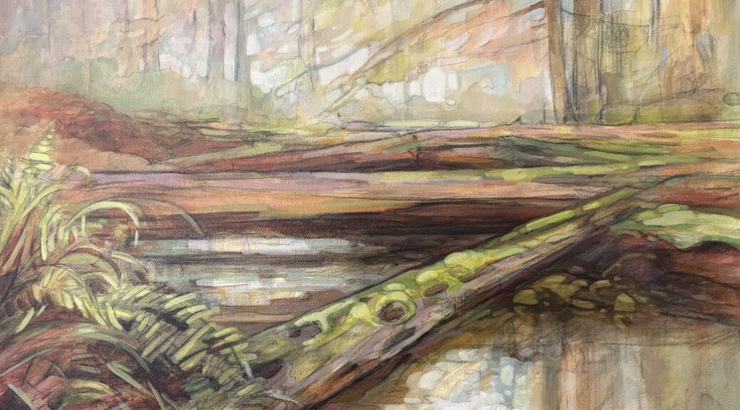

[Article by Christine and Cec Robinson, reprinted from Tideline; the audio version of this story includes not only the text of this article, but an interview with the authors about the history of Cortes Streamkeepers and the importance of watershed protection. The feature image is a cropped area from an original painting of James Creek by Desiree Bond, see end notes.]
Controversy continues to simmer over Island United’s application for an ambitious expansion of the Cortes Pit (a gravel and rock quarry in Whaletown). Cortes Currents has been covering the issue; this article is the third in a series.
Note: There has been some confusion over the deadlines for commenting on the permit application. There are two different deadlines for two different application processes.
- One is strictly a mining application and is terse and minimalist. Its deadline is May 8th. BC government confirms that this means comments must be received before midnight on May 8th.
- The other is an application for expansion and mining use of a Crown Land lease. It is more elaborate and includes the much-quoted “Aggregate and Quarry Management Plan” which contains many errors and misstatements. Its deadline is May 14th.
This article addresses misstatements or deficits in the Management Plan document regarding streams and fish. The document states that “There are no permanent or ephemeral watercourses or wetlands located within the tenure. No water will be discharged to the environment during or post-operation. An unnamed creek runs 15m to the east of site […] There are no aquatic disturbances that will result in any fish habitat being affected by the development. “
Local Streamkeepers Christine and Cec Robinson are not so sure. They feel that the Management Plan misrepresents the situation on the ground in the quarry area. Cortes Streamkeepers have been monitoring and collecting data on Cortes streams and fish spawning patterns for 40 years. This is what they have to say about the quarry expansion.
Stream-Truthing
Island United proposes to expand the footprint and scale of the existing granite quarry in Whaletown at 50°06’47.13″N 125°00’07.84”W and has applied to the relevant Ministries for approval, submitting an Aggregate and Quarry Management Plan (June 27, 2025).
Cortes Island Streamkeepers hope this article will address incorrect and misleading information in that Management Plan about fish presence and streams in the immediate vicinity of the proposed mining and quarry expansion. CI Streamkeepers were not consulted by Island United, nor is there any reference in the A & Q Management Plan to the James Creek watershed and the years of salmon enhancement work done in the creek.
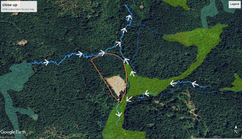
The headwaters of two watersheds swirl all around the existing quarry. James Creek, also known as Carrington Creek by Klahoose, begins in the wetlands between the existing quarry and the community forest cutblock, ‘Green Mountain’, and flows northward through the Children’s Forest into Carrington Lagoon. The James Creek watershed is the largest by area on Cortes Island and is the least impacted by development and human activity of all Cortes watersheds.
Hume Creek shares its headwaters with James Creek and flows into the Gorge Harbour. Its streamcourse can be picked up immediately south of the entrance to the quarry. Of note, Hume Creek has 2 registered water licenses and provides drinking water to 3 households.
Additionally, there are several small creeks and wetlands surrounding the quarry (see attached map); one of them is informally known as Quarry Creek which is shown on the A & Q Management Plan as wrapping around the northern boundary of the proposed expansion. Recent stream-truthing has shown that it is a tributary flowing east into James Creek, and by definition, is considered fish-bearing.
Stream-truthing the watersheds and watercourses on Cortes Island has long been overdue, especially with the increase of serious drought conditions and pressure from human development. The Cortes Island Aquifer Health Assessment (GW Solutions Inc.) and The Cortes Community Ecosystem Mapping (CCEM) Project were both completed in 2025, and demonstrate a serious need to update mapping of all land and water features as the critical and foundational base to inform all development on Cortes. This is currently underway, but far from complete.
Fish Presence
Fish presence in James Creek, specifically, and in all major creeks on Cortes have been documented for many years. Spawning records of yearly spawning salmon returns, yearly restocking records and live fry trapping have been recorded by Fisheries & Oceans, Klahoose Fisheries and streamkeepers since 1984.
Chum salmon spawn in the lower reaches of James Creek, while coho salmon and coastal cutthroat trout are present in the headwaters and throughout the entire creek, with coho spending the first year in the upper reaches of James Creek before moving out to the saltwater, and cutthroat trout being resident, not migratory. Upper James Creek and surrounding wetlands are especially ideal for coho and cutthroat trout. There is one anecdotal observation by a streamkeeper and another Cortes Islander of a spawned-out coho in the wetland immediately west and adjacent to the existing quarry. Documentation of cutthroat trout in Hume Creek is also confirmed.
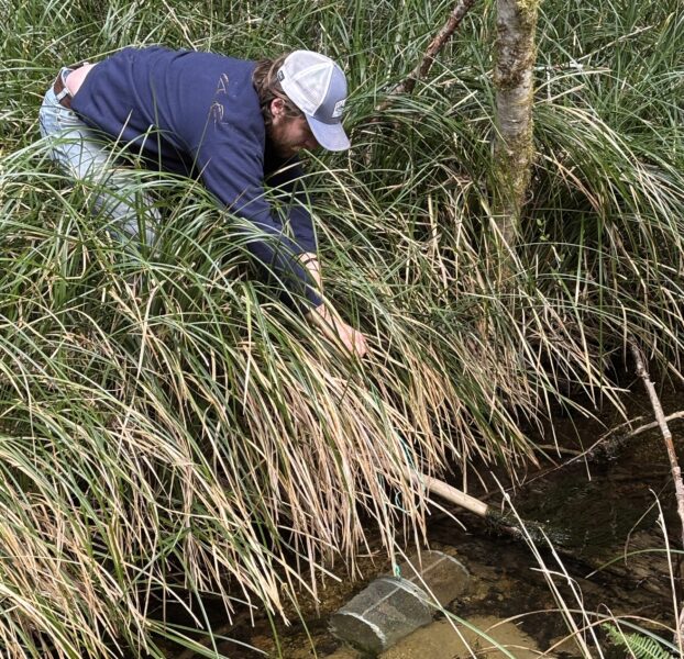
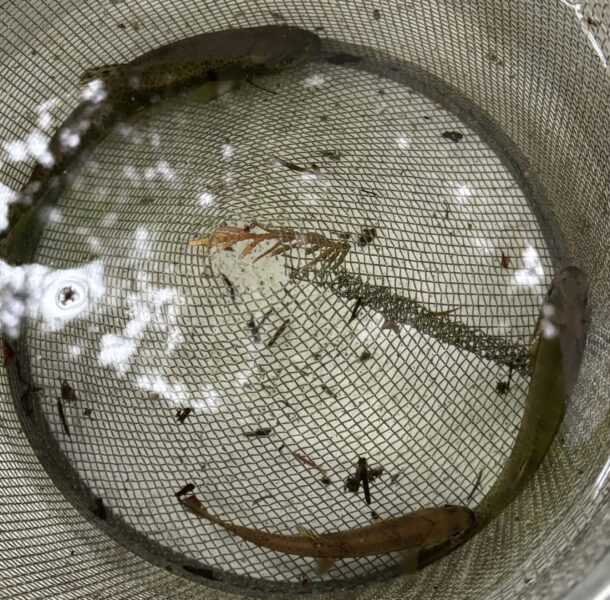
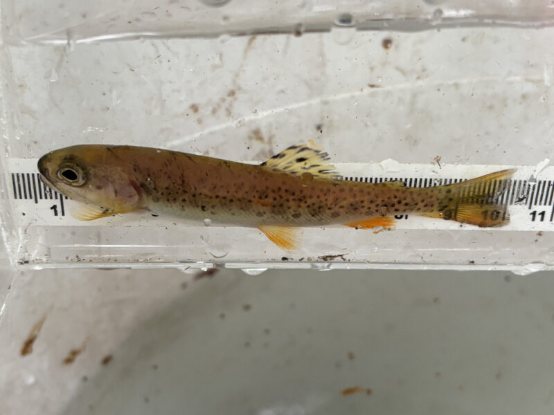
Hot off the press is the April 2026 live fry trapping in which 3 of the 4 gee-traps (the standard, harmless fish traps used by fisheries to verify fish & species presence) enticed a total of 7 cutthroat trout (see photos), including the largest cutthroat trout that streamkeepers have ever documented – 17 centimeters long and overlarge to fit in the viewing scope. Cutthroat trout numbers appear to be stable on Cortes at this time. However, they are blue listed (at risk) in BC due primarily to habitat loss. Their dependence on small streams for spawning and rearing makes them especially vulnerable, as small streams are easily altered or destroyed and their protection is often overlooked in planning residential, agricultural, and industrial developments.
A quick, selective spotlight on James Creek fish data by streamkeepers shows the following records:
1985 – 188 chum spawners counted
2016 – 217 chum spawners counted
2024 – 219 chum spawners counted
1990 – 10,000 coho stocked
1993 – 90,000 coho stocked
2024 – 10,000 chum eggs stocked
2025 – 6,000 chum eggs stocked
Fisheries & Oceans and Cortes Streamkeepers completed a spawning gravel assessment of James Creek in 2020. This resulted in a 5 – year project (2020 – 2025) to increase natural spawning beds and was a collaboration between Fisheries & Oceans, Mainroad Highways Contracting, Mosaic Forest Management, FOCI and Cortes Streamkeepers. An heroic effort by 48 Cortes volunteers depositing spawning gravel into the mid-section of James Creek using zipline, buckets, wheelbarrows, and hand increased the spawning potential for chum & coho. Additionally, in December 2024 & 2025, twelve streamkeepers used the excess spawning gravel to build redds in the creek and deposit a total of 16,000 chum eggs, many of which were taken from chum spawning in Basil Creek
The Klahoose and Tla’amin Fisheries have been essential to the availability of chum eggs for James Creek, and CI Streamkeepers continue to be thankful for this ongoing collaboration.
There is clearly, irrefutable evidence that James Creek is an active fish-bearing creek, recognized & identified by Fisheries & Oceans as important enough to monitor spawners, enhance stocks and improve spawning beds for over 40 years.
Summary
It appears that the following conditions and questions were not considered or were inadequately addressed by Island United in their Aggregate and Quarry Management Plan:
• Where is a hydrological study, completed by a professional geologist, of groundwater & water table levels in the James and Hume Creek watersheds?
• Where is a stream assessment, done by a registered professional biologist, of stream accuracy, wetlands and riparian areas, and fish presence and habitat?
• What seasonal data was completed in the 2 watersheds to properly assess the impacts of industrial development given the increasing frequency of extreme weather events (ie. drought, flooding) and the subsequent impact on streams & fish?
• The claims of closed-containment tanks raise multiple questions of possible equipment failure, discharge water, sediment pooling, run-off, spills and dumping, and issues not considered; all potentially harmful to creeks and fish.
• The use of herbicides in the Management Plan is unacceptable anywhere on Cortes island and directly undermines fish and stream health.
Cortes Streamkeepers are strongly opposed to the Aggregate and Quarry Management Plan (June 27, 2025). The James and Hume Creek watersheds, wetlands and creeks must be protected: both creeks are proven fish-bearing creeks; extensive wetlands are supported within these watersheds; the Cortes Island aquifer is not well enough documented; and climate change underlies the necessity of the highest level of protection of the water resources on Cortes Island.
Cortes Streamkeepers will be submitting a more comprehensive report to the Public Engagement, Ministry of Mining, BC Government site.
Cortes Streamkeepers also wish to thank all the streamkeepers, stream-truthers, ground-truthers and community volunteers who have given so much of their time over many years for the love of Cortes fish & creeks, and who made possible the compilation of this report.
Christine & Cec Robinson,
Coordinators of Cortes Streamkeepers; April 27, 2026
There are just so many unanswered questions.
— Christine Robinson, in interview
[Featured image: painting by Desiree Bond, 2012, made during a workshop on Cortes island with Robert Bateman. Ms Bond’s note on the painting: “We walked and painted in the forest for two days. At the end of a great weekend, I sat down on the shallow banks of James Creek and did a quick sketch, In the end, it was what I felt most represented my impression of the Children’s Forest. This painting is based on that sketch.” Other photos and map by courtesy of Cortes Streamkeepers.]