
Editor’s note: The well monitoring currently underway Quadra Island is a model of how this could be done on Cortes.

A joint We Wai Kai/ ICAN Water Security team has been monitoring Quadra Island wells for the past month as part of a much larger project to calculate the island’s water budget.
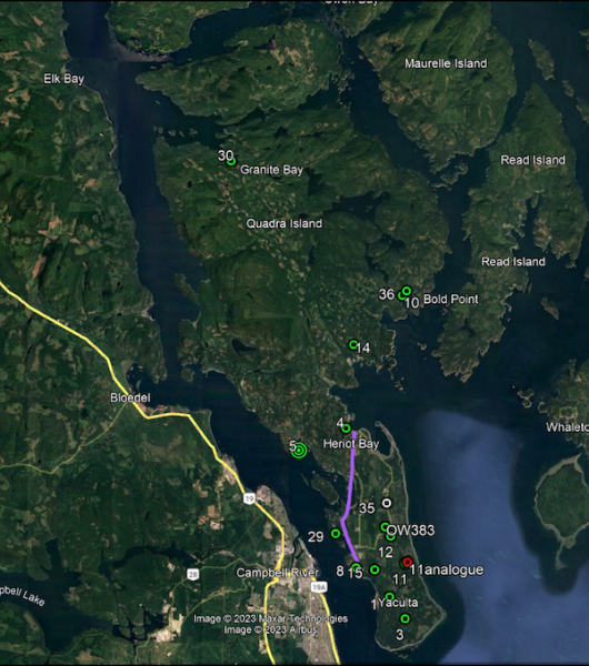
“At the moment 13 wells are being monitored, and another three or four will be added from Cape Mudge. So there will probably be 17 deeper wells and Eileen McKay, particularly, has been saying for a while that we need to add shallow wells. We’ll be doing that hopefully this year,” explained Nick Sargent, a former professional hydrologist who is overseeing the well monitoring.
Red Williams Well Drilling Ltd was involved in this part of the project.
“Just before Christmas, Red Williams offered to help. So we went around and installed what we call drop pipes, so plastic tubes down in the wells. Then we drop down, on basically a fishing line, these little monitoring devices. They’ve been running since mid-December, and we hope to do the first reading in the next couple of weeks or so. Once we’ve read them and we’re okay that they’re working and they’re set at a reasonable depth, we’ll probably read them every four to six months.”
This project was made possible thanks to a Indigenous Watershed Grant which is being administered by Jason Price of the We Wai Kai. Some of the other components are monitoring the island’s rainfall and streamflow, as well as mapping wetlands.
“The water security team was started a few years back, before I joined. I think with the realization that issues that had arisen with water supply where there were too many people and too little supply. We’re not at that stage on Quadra and probably not on Cortes either, but it’s good to get a handle on the ground water supply before problems arise.”
The well monitoring component originated with Eileen McKay, leader of the ICAN Water Security Team, and Chris Wellstein.
Nick Sargent: “Before I joined, people had been if they were interested in having their wells monitored, and there was a pretty decent response to that.”
CC: How do you monitor wells?
Nick Sargent: “For shallow wells, you can just remove the well cover and measure from the top of the lid or whatever you select down to the water level. Doing that regularly will give you some idea of what’s going on.”

“For deep wells we’re using automated water level monitors made by Solinst in Waterloo. They look about the size of a cigar tube. They have a pressure transducer in them, and they have a little computer and a battery and a 10 year battery life. They record as frequently or as infrequently as you want. We’re going to record every half hour on the ones that we’ve installed.”
CC: In the case of shallow wells, how often would you advise checking the levels?
Nick Sargent: “Doing it every day would be good. If you put in an automatic monitor, you can measure more frequently than that, and you might see things like the tidal influence.”
CC: Why monitor drilled wells, I thought there’s no problem with them?
Nick Sargent: “There’s no problem, at least we don’t believe there’s any problem, but to develop a groundwater model of the island, you’d need that data. I think typically you might be more interested in that data than in data from the shallow wells. One problem with the shallow wells is there’s often not any information on what the geology is. They were just dug in with an excavator and there’s often not any information on how they were completed. Typically if you’re going to monitor a well, It’s good to know what the geological setting is.”
CC: How long has this project expected to last?
Nick Sargent: “We think that we would collect data for three years, which will give us at least a few annual cycles, and it’ll give us quite a lot of seasonal changes. Then, assuming that we can get grant money, we would, at that point, hand this information over to a logical consultant to complete the interpretations that we will require.”
CC: How big of an area are you monitoring?
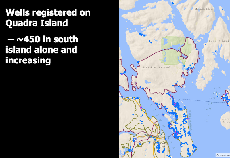
Nick Sargent: “We have 13 wells, pretty much equally divided between the North Island and the South Island. The South Island aquifer area is only about 34 square kilometers, and the whole of Quadra, depending on which document you read, is about 300 square kilometers. So we have a fairly high concentration in the South Island where most of the population is, and a lesser concentration in the North Island. Really the well selections came down to which wells people were willing to let us use, and which ones we also could get information on, like well logs, primarily.”
CC: So you’ll have three years of data, which would give you a picture of what it was like from 2024 to 2027.
Nick Sargent: “There’s also a provincial monitoring well in the center of the South Island. That’s been running since, I think, 2010, but there’s a monitoring well there as well that we can use to extend in that direction.”
“If we develop this model, we would impose on it different climate change scenarios and try and evaluate what the impacts will be on groundwater levels.”
CC: You’ve got a ‘point of time.’ How relevant would that be in another 10 years? Or would you have to do it all over again?
Nick Sargent: “It’s not exactly a point in time. Part of the reason to get a decent data set is to allow you to calibrate the model properly. If we can calibrate the model so that it reflects the present day changes that we’ve been able to collect, then there’s a better chance that you can then use the model to say, ‘okay. We’re going to reduce the recharge by half on the island. What’s the impact going to be on the well?’ Or ‘we’re going to increase the amount of development on the island and the amount of groundwater withdrawal. What will be the impact of those changes?'”
“You’re right, it’s a small amount of time, but it does allow us to calibrate the model. We can believe that it responds to the data that we have in the manner that we expect.”
“One other thing I should point out is this data is actually of the people that have agreed to have their wells monitored. The data actually will be on a provincial website and anyone can go and look at the data and download it and play with it if they like to do that.”
CC: Do you know when it will be going live?
Nick Sargent: “Once we get our first lot of data, it should go live then. We’ve discussed this with the province, but I don’t know if there’s any lag between us saying, these are the wells we’re going to use and these are the data and it’s going up on the website. I don’t think there’ll be much of a lag.”
Top image credit: Nick Sargent and Red Williams
Links of Interest in this series:
- How the WE Wai Kai/ ICAN Water Security Team Partnership came into being
- Studying The Water Budget For Quadra Island; a model for the future
- Mapping Wetlands on Quadra, and what that means on Cortes
Sign-up for Cortes Currents email-out:
To receive an emailed catalogue of articles on Cortes Currents, send a (blank) email to subscribe to your desired frequency:
- Daily, (articles posted during the last 24 hours) – [email protected]
- Weekly Digest cortescurrents – [email protected]